Cowardice Kills (0)
2/10/22 •
Government officials are tasked with responsibility of protecting the health of every student, of every teacher, of every worker—and of everyone those students, those teachers, and those workers might come into contact with. Their efforts to make mask-wearing optional boosts the sense of entitlement of those who prioritize the exercise of their parental whims over the legitimate health interests of everyone else.
As lessons go, it is a horrid lesson to teach our students. The answer to the Biblical question, “Am I my brother’s keeper,” is, according to the example given by the governor, the school board, and the state legislature, “No. Whatever happens to my brother is his problem.”
Recent Posts

A Meditation on the Nature of Sacrifice (0)
9/14/21 •
[Editor’s Note: I submitted a version of this as a column to my newspaper shortly after Memorial Day 2020, but recently found out it had never run. It was relevant to the political chaos with respect to our COVID-19 response then. Sadly, it remains relevant now. I have updated it somewhat for where the dis-United States seems to be in September 2021.
The Murder of Glen Tompkins: A Personal Story (0)
3/10/21 •
SHREVEPORT, La.—I’m not sure which staff photographer snapped the photo of my dad, George M. Lawrence, but one of them caught him checking out a wire photo on the copy desk of The (Shreveport, La.) Times. This was circa 1980, because The Times switched from hot type to cold type about 1978: The dreadful computer […]

It’s “OK,” dammit! (0)
9/15/18 •
MECHANICSVILLE, Va. — For those who react without reading, go ahead and flip out. You will only prove yourself a fool. But it is time I — and I hope others — take a stand. You see the picture. I am holding my hand in a simple gesture, a thumb and forefinger making a circle, […]
What race(s) should I own? (0)
8/13/17 •
MECHANICSVILLE, Va. – Today, with clashes between white supremacists and neo-Nazis and those who oppose them in nearby Charlottesville, Virginia, today, I had something happen to me that feels like a total betrayal. Today, an African-American man told me – despite my pointing out my ancestry and life experience – that I had no business […]
The Art of Receiving (or Not) a Critique (0)
12/31/16 •
EDITOR’S NOTE: This was originally posted to Facebook, but I thought this essay deserved a more permanent home—DML. MECHANICSVILLE, Va.—Attention my fellow writers: I probably should have brought this up for Festivus, but I didn’t. Yet I feel the need to get something off my chest before the year is out. When you ask someone […]

How have I been harmed by Trump voters? (0)
12/13/16 •
MECHANICSVILLE, Va. – The Trump phenomenon has unleashed an especially pernicious strain of vileness in this nation. It’s not the unjustified and unconstrained ego and arrogance. It’s not the celebration of greed, of wealth accumulated at the expense of tens—maybe hundreds—of thousands of hard-working people. It’s not the flagrant disregard for the hard-won achievements of […]
The Election is Over: Where to Go from Here (0)
11/11/16 •
MECHANICSVILLE, Va.—Election Day is over. The better side lost, and many of us are stunned, grieving, angry, confused. We are like the Steve McQueen character in “The Sand Pebbles.” We were on the verge of success, of getting the power we needed to continue moving this country forward, but now we are bleeding out in […]

Lies, damned lies, and abortion statistics (0)
9/11/14 •
MECHANICSVILLE, Va.—The National Review Online, in a recent post best described as a slimy attack on a woman running as Democratic nominee for governor of Texas, demonstrated the maxim that: “There are three kinds of lies: lies, damned lies, and statistics” (Twain 1907, p. 471). In a blog post entitled, “Wendy Davis’s Convenient Abortion Stories,” […]
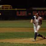
Season’s End (0)
5/29/14 •
MECHANICSVILLE, Va.—When I was much younger, dumber, and far more arrogant than I am at 52, I worked as a sports writer for a daily newspaper in Shreveport, Louisiana. While there, I suffered from a disease common to my profession: that covering high schools was beneath my (in my mind only) vast talent. I have […]

Review: Busted (0)
4/12/14 •
Wendy Ruderman and Barbara Laker Busted: A Tale of Corruption and Betrayal in the City of Brotherly Love New York: HarperCollins, 2014 ISBN: 978-0-06-208544-3. 256 p. $25.99 (US) MECHANICSVILLE, Va.—If you’re too busy to read my entire review of Wendy Ruderman and Barbara Laker’s book, Busted: A Tale of Corruption and Betrayal in the City […]
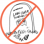
The Future of Long-Form Journalism in the Age of the Digital Publishing Platform (0)
1/10/14 •
MECHANICSVILLE, Va. — This is a terrifying time for ink-stained wretches like me. I grew up in the newspaper business, with my earliest memories back in the age of the linotypes—massive, probably incredibly toxic typewriters that spewed out lines of hot head rather than pigmented stamps on paper—were the primary method of outputting the copy […]
Survey: What Is a Landscape? (0)
5/28/13 •
A discussion recently erupted on a scientific listserv I subscribe to about whether the term “landscape” is too confusing for most people to understand. Given a long-abiding interest in the subject of “landscape,” I designed this quick survey for to assess public perceptions of the term. The survey is quite short. Thank you for taking […]
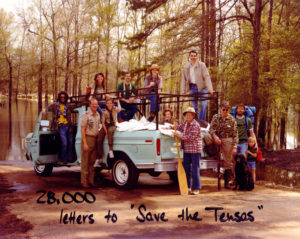
New Frontiers (0)
10/30/12 •
[EDITOR’S NOTE: This is the text of a speech I gave at the 30th Friends of the Library Book & Author Dinner at the Indian Creek Yacht and Country Club in Kilmarnock, Va., on October 29, 2012.] The theory of continental drift is 100 years old this month. Alfred Wegener, the father of continental drift […]
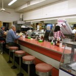
Drugstore soda fountains: A bit of nostalgia, a lot of home (Comments Off on Drugstore soda fountains: A bit of nostalgia, a lot of home)
3/26/11 •
MECHANICSVILLE, Va. — Three years ago, Renee Bond started a day confused. She left for her waitressing job an hour early, took a wrong turn, and found herself in front of Mechanicsville Drug Store. She saw that it had a soda fountain inside. She went in to check it out. By accident, Bond found herself […]
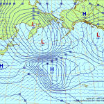
Worried about Japanese nuclear fallout? (1)
3/12/11 •
EDITOR’S NOTE: I have added an explanation on now to interpret the charts in a comment at the bottom of the post. MECHANICSVILLE, Va. — I woke up with the news of the explosion at the Fukushima Daiichi nuclear plant in Okuma, Fukushima Prefecture, Japan, and cooling troubles at the nearby Fukushima Daini nuclear plant […]

Hallelujah! Notes from the Abyss restored! (0)
2/11/11 •
MECHANICSVILLE, Va. — Screams of anguish have changed into screams of joy. The management is pleased to announce that it has recovered from its tremendous lapse of intelligence of early Saturday morning when it deleted the database that contained Notes from the Abyss—without a recent backup of the site. After several days of sustained effort, […]
Hello world! (0)
2/05/11 •
MECHANICSVILLE, Va — Hello is not exactly what I wanted to say. In fact, I wanted to say something unprintable. Early Saturday morning I accidentally deleted my WordPress database. I had no backup. Now I am reconstructing the blog using archived materials from both its WordPress and Blogger incarnations. So far, I think I have […]
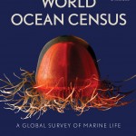
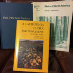
Review: World Ocean Census (0)
11/25/10 •
Darlene Trew Crist, Gail Scowcroft, and James M. Harding Jr. World Ocean Census: A Global Survey of Marine Life Buffalo, N.Y.: Firefly Books, 2009 ISBN: 978-1-555407-434-1. 256 pp. $40.00 (US) LEXINGTON, N.C.—For the past 10 years, more than 2,700 scientists from more than 80 countries have been engaged in one of the most ambitious projects […]

RIP, Ronnie James Dio (0)
5/10/10 •
Rest in peace, Ronnie James Dio. I first heard you with Rainbow on a late-night radio program in the 1970s. Being a guitar geek, I was of course thrilled by Ritchie Blackmore’s playing. But the majesty and … beauty for lack a better word … of your voice has haunted and enchanted me in the […]
Older Posts
- This Blog has changed
- Censorship by Amazon.com
- Review: Letters to a Young Journalist
- Review: Battle for the Southern Frontier
- Ascension Island Expedition — Ascension Island, Day Three: The Dive
- Ascension Island Expedition — Ascension Island, Day Two: Green Mountain
- Ascension Island Expedition — Ascension Island, Day Two: The Beach
- Ascension Island Expedition — Ascension Island, Day One
- Ascension Island Expedition — Berwick-Upon-Tweed to RAF Brize Norton
- Ascension Island Expedition — Strike! (Thurso to Berwick-Upon-Tweed)
- Ascension Island Expedition — Orkney
- Ascension Island Expedition — Caithness
- Ascension Island Expedition — Edinburgh to Thurso
- Ascension Island Expedition — London to Edinburgh
- Ascension Island Expedition — Mechanicsville to London
- Weird, but true (another bear story)
- The search for a missing airliner
- Welcome to the newly converted
- The story behind the image — Tramps
- Lindzen needs a reality check on climate change
- No time to sit on the sidelines
- Imminent eruption of Mount Merapi
- Welcome to my Blog
Featured Categories
Animals»
1/05/07 •
Weird, but true (another bear story)12/30/06 •
Welcome to the newly converted
Archaeology»
6/03/07 •
Ascension Island Expedition — Orkney3/13/07 •
Ascension Island Expedition — Caithness
Arctic»
12/30/06 •
Welcome to the newly converted
Ascension Island»
1/27/08 •
Ascension Island Expedition — Ascension Island, Day Three: The Dive1/20/08 •
Ascension Island Expedition — Ascension Island, Day Two: Green Mountain1/20/08 •
Ascension Island Expedition — Ascension Island, Day Two: The Beach6/22/07 •
Ascension Island Expedition — Ascension Island, Day One6/03/07 •
Ascension Island Expedition — Berwick-Upon-Tweed to RAF Brize Norton
Berwick-upon-Tweed»
Book Review»
4/12/14 •
Review: Busted11/25/10 •
Review: World Ocean Census3/18/09 •
Review: Letters to a Young Journalist3/08/09 •
Review: Battle for the Southern Frontier
Caithness»
3/13/07 •
Ascension Island Expedition — Caithness3/13/07 •
Ascension Island Expedition — Edinburgh to Thurso
Climate»
12/30/06 •
Welcome to the newly converted6/26/06 •
Lindzen needs a reality check on climate change
Diving»
Edinburgh»
Endangered Species»
12/30/06 •
Welcome to the newly converted
England»
6/03/07 •
Ascension Island Expedition — Berwick-Upon-Tweed to RAF Brize Norton6/03/07 •
Ascension Island Expedition — Strike! (Thurso to Berwick-Upon-Tweed)3/13/07 •
Ascension Island Expedition — London to Edinburgh3/13/07 •
Ascension Island Expedition — Mechanicsville to London
Indonesia»
1/03/07 •
The search for a missing airliner12/22/06 •
The story behind the image — Tramps5/15/06 •
Imminent eruption of Mount Merapi
Music»
5/10/10 •
RIP, Ronnie James Dio
Natural Hazards»
5/15/06 •
Imminent eruption of Mount Merapi
Orkney»
6/03/07 •
Ascension Island Expedition — Orkney
Rocky Mountains»
1/05/07 •
Weird, but true (another bear story)
Scotland»
6/03/07 •
Ascension Island Expedition — Strike! (Thurso to Berwick-Upon-Tweed)6/03/07 •
Ascension Island Expedition — Orkney3/13/07 •
Ascension Island Expedition — Caithness3/13/07 •
Ascension Island Expedition — Edinburgh to Thurso3/13/07 •
Ascension Island Expedition — London to Edinburgh
Scottish Highlands»
6/03/07 •
Ascension Island Expedition — Strike! (Thurso to Berwick-Upon-Tweed)3/13/07 •
Ascension Island Expedition — Caithness3/13/07 •
Ascension Island Expedition — Edinburgh to Thurso
Volcanism»
5/15/06 •
Imminent eruption of Mount Merapi

You must be logged in to post a comment.